


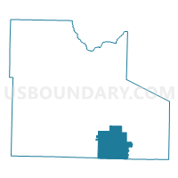
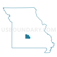
Competition Voting District, Laclede County, Missouri
About
Outline

Summary
| Unique Area Identifier | 608913 |
| Name | Competition Voting District |
| County | Laclede County |
| State | Missouri |
| Area (square miles) | 38.70 |
| Land Area (square miles) | 38.57 |
| Water Area (square miles) | 0.13 |
| % of Land Area | 99.66 |
| % of Water Area | 0.34 |
| Latitude of the Internal Point | 37.52106790 |
| Longtitude of the Internal Point | -92.46545630 |
Maps

Graphs
Select a template below for downloading or customizing gragh for Competition Voting District, Laclede County, Missouri


Neighbors
Neighoring Voting District (by Name) Neighboring Voting District on the Map
- Delto Voting District, Laclede County, MO
- Gasconade Voting District, Laclede County, MO
- Grovespring Voting District, Wright County, MO
- Manes Voting District, Wright County, MO
- Nebo Voting District, Laclede County, MO
Top 10 Neighboring County Subdivision (by Population) Neighboring County Subdivision on the Map
- Osage township, Laclede County, MO (1,733)
- Gasconade township, Laclede County, MO (905)
- Franklin township, Laclede County, MO (748)
- Montgomery township, Wright County, MO (548)
- Elk Creek township, Wright County, MO (370)
Top 10 Neighboring Elementary School District (by Population) Neighboring Elementary School District on the Map
Top 10 Neighboring Unified School District (by Population) Neighboring Unified School District on the Map
- Lebanon School District, MO (24,821)
- Hartville R-II School District, MO (4,468)
- Plato R-V School District, MO (3,401)